Polar Books Catalogue
-
Sections : Antarctic; Arctic; Journal of the Manchester Geographical Society; Maps; Miscellaneous; Mountaineering; General Polar; Scott; Other travel; Whaling;
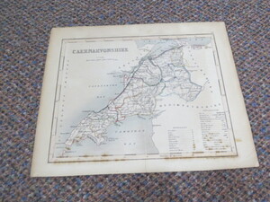

Reference 3448 (1713) Category Maps; Author Archer, J (Drawn and Engraved by) Title Antique Map WALES CAERNARVONSHIRE Scale approximately 1:402,336 Publishing Information London: J. Archer, circa 1870s Description No date but possibly circa 1870s as map showing Caernarvonshire with the railway from Llandudno Junction to Porthduilleyn. With boundarys of the Boroughs, Hundreds and Counties. Some spotting, map size 230mm x 185mm. Price £5.00 Keywords ISBN Add this to your basket
