Polar Books Catalogue
-
Sections : Antarctic; Arctic; Journal of the Manchester Geographical Society; Maps; Miscellaneous; Mountaineering; General Polar; Scott; Other travel; Whaling;

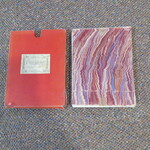
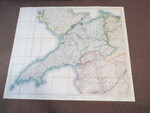

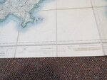
Reference 3965 (2213) Category Maps; Author Ordnance Survey Title Ordnance Survey Map of Carnarvonshire and Part of Anglesey and Merionith Third Edition. One Inch to One mile 1:63,000 Publishing Information Southampton: Ordnance Survey, 1905 Description Ordnance Survey, 1905. One Inch to One mile 1:63,000. A large copy of the Third Edition showing all of the county of Carnarvonshire along with parts of Anglesey and Merionith. Originally surveyed in 1887 to 1888, published in 1895 with a revision in 1903 and published in 1905. Mounted in sections (40) on cloth and folded in marbled card covers in slipcase with Edward Stanford label. Map measures 115 & 135cm wide and 111cm deep and comprises of whole or parts of OS map numbers 38,39, 43,44 &46. An unusual example that displays the whole of the County of Carnarvonshire as was. Slip case is worn and splitting. Price £100.00 Keywords Stanford S1-Map ISBN Add this to your basket
