Polar Books Catalogue
-
Sections : Antarctic; Arctic; Journal of the Manchester Geographical Society; Maps; Miscellaneous; Mountaineering; General Polar; Scott; Other travel; Whaling;
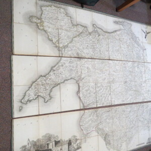

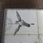
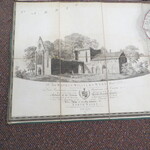
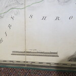
Reference 3985 (2226) Category Maps; Author Evans, John (Engraved by Robert Baugh) Title [Large Map on Linen of North Wales] To Sir Watkin Williams-Wynn Bart. LLD, Member Of Parliament, Lord Lieutenant And Custos Rotulorum Of The Counties Of Denbigh.... This Map Of The Six Counties Of North-Wales..Scale: 3/4 inch to one statute mile Publishing Information Lwynygroes: Published as the Act directs, June 1. 1795 John Evans Description 1795 Map: To Sir Watkin Williams-Wynn Bart. LLD, Member Of Parliament, Lord Lieutenant And Custos Rotulorum Of The Counties Of Denbigh And Merioneth, Colonel Of The Ancient British Fencible Cavalry, Steward Of The Hundreds Of Bromfield And Yal And Vice President Of The Welsh Charity School This Map Of The Six Counties Of North-Wales Is Most Humbly Inscribed By His Obedient Humble Servant John Evans. Evans' large-scale map engraved map of North Wales, dissected and laid on lined. Scale: 3/4 inch to one statute mile (1:190080). In 3 sections. 2 sections approx 54cm x 180cm, 1 section 50cm x 180cm, total size approx 158cm x 180cm. Scale 3/4 inch to one statute mile. No slip case. Montgomery Welshpool in ink on reverse of linen on one section. Border a little worn in places. The small population of the area combined with the mountainous terrain predetermined the type of map that would result from Evans' survey, a task that must have proved enormous over such difficult ground. The thoroughness of this survey is indicated by the way he continues the detail on the east of the map, into Cheshire and Shropshire. The engraver of the map, Robert Baugh, adopted a similar approach for the only other large-scale survey he was involved in, that of Shropshire. The left hand sheet has an engraving Vale Crucis Abbey and the dedication to Sir Watkin William Wynn, Lord Lieutenant of Denbigh and Merioneth, who purchased 100 copies himself. With hills and mountains dominating the map. The top right has a lovely engraving of a bird of prey holding the Compass Arrow pointing north. The largest map to appear prior to the publication of the Ordnance Survey, it is surprising Evans' only major cartographical contribution: a highly competent survey that deservedly received recognition from the Society of Arts. Roger 559. Price £3750.00 Keywords ISBN Add this to your basket
