Polar Books Catalogue
-
Sections : Antarctic; Arctic; Journal of the Manchester Geographical Society; Maps; Miscellaneous; Mountaineering; General Polar; Scott; Other travel; Whaling;
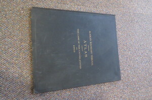
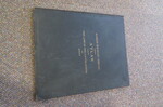
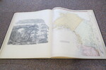
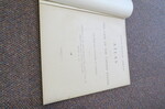
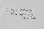
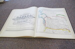
Reference 4018 (2255) Category Arctic; Author U.S. Government Title ALASKAN BOUNDARY TRIBUNAL: Atlas Accompanying the Case of the United States Before the Tribunal Convened at London Under the Provisions of the Treaty between the United States of America and Great Britain, Concluded January 24, 1903. Publishing Information Washington D.C: Government Printing Office,1903. Description SIGNED PRESENTATION COPY: Full Title: ALASKAN BOUNDARY TRIBUNAL. Atlas Accompanying the Case of the United States Before the Tribunal Convened at London Under the Provisions of the Treaty between the United States of America and Great Britain, Concluded January 24, 1903. 1st Edition, 1st printing. Very large folio (46cm). Original covers, titled in gilt on front, plain endpapers; [6]pages(List of maps and biographical notes of Cartographers; 25 maps, some in color. Minor shelf wear. Presentation copy to Henry S Wellcome with the compliments of John W Forster. (U.S. Secretary of State Government). Reproductions of maps used in 1903 border disputes with Britain, showing the American claim to the land; effectively, a cartographic history of Alaska. When the U.S. purchased Alaska from Russia in 1821, it inherited a dispute over the territory's border with British Columbia. The Klondike Gold Rush of 1897-98 exacerbated tensions until the 1903 Hay-Herbert Treaty, under which the nations entered arbitration to resolve the dispute. The arbitration's conclusion favored the United States sparking Canadian frustration that Britain had not better defended its interests.This atlas presents official facsimiles of the maps presented by the U.S. in the arbitration process. 21 are facsimiles of historical maps from Russian, French, German, British, Canadian, and American atlases, dating between 1798 and 1863; many are depicted with facsimiles of title pages from the source atlases. The remaining four maps were produced in 1903 by the U.S. Coast and Geodetic Survey, including one depicting the locations of Native American villages along the border. Background Information: Final report of the Honorable John W. Foster, agent of the United State. John Watson Foster (March 2, 1836-November 15, 1917) was an American diplomat and military officer, as well as a lawyer and journalist. His highest public office was U.S. secretary of state under Benjamin Harrison, although he also proved influential as a lawyer in technically private practice in the international relations sphere. Sir Henry Solomon Wellcome (21 August 1853-25 July 1936) was an American pharmaceutical entrepreneur. He founded the pharmaceutical company Burroughs Wellcome & Company with his colleague Silas Burroughs in 1880 which is one of the four large companies to eventually merge to form GlaxoSmithKline. He left a large amount of capital for charitable work in his will, which was used to form the Wellcome Trust, one of the world's largest medical charities. He was a keen collector of medical artefacts which are now managed by the Science Museum, London, and a small selection of which are displayed at the Wellcome Collection. (Wikepedia) Price £900.00 Keywords ISBN Add this to your basket
