Polar Books Catalogue
-
Sections : Antarctic; Arctic; Journal of the Manchester Geographical Society; Maps; Miscellaneous; Mountaineering; General Polar; Scott; Other travel; Whaling;
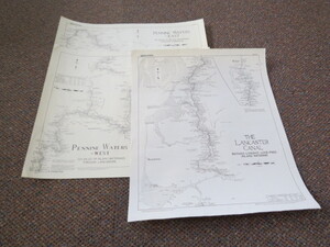


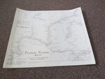
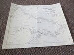
Reference 4046 (2281) Category Maps; Author Smith, Douglas M., Title Set of 3 Lockmaster Maps: No.27-The Lancaster Canal, Nos. 2&3 Penine Waters West and East Publishing Information Warwick: Smith, Douglas M., with permission of Ordnance Survey1989 Description Based on the Ordnance Survey maps of the time. Areas Covered. Map 2: Lancaster Canal (Preston to Hollowforth Aqueduct), Leeds & Liverpool Canal (Liverpool to Skipton including Rufford & Leigh Branches), Bridgewater Canal (Leigh to Manchester Castlefield Junction), Rochdale Canal (Manchester Castlefield Junction to Ducie Street Junction), Ashton Canal (Manchester Ducie Street Junction to Droysden). Map 3. Leeds & Liverpool Canal (Nelson to Leeds), Aire & Calder Navigation (Leeds to Wakefield), Calder & Hebble Navigation (Wakefield to Sowerby Bridge), Rochdale Canal (Sowerby Bridge), Huddersfield Broad & Narrow Canals (Cooper Bridge to Marsden). Map 27. The whole of The Lancaster Canal including the now derelict section Tewitfield to Kendal. All maps Scale: Scale 1" to 2 miles. Size 16" x 19". Nice clean condition. The famous series of canal & inland waterway maps printed at 1/2" to the mile covering most of the UK. All the important information for boaters, canal enthusiast, walkers. These detailed guides are also great works of art. Price £15.00 Keywords ISBN Add this to your basket
