Polar Books Catalogue
-
Sections : Antarctic; Arctic; Journal of the Manchester Geographical Society; Maps; Miscellaneous; Mountaineering; General Polar; Scott; Other travel; Whaling;

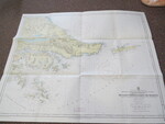
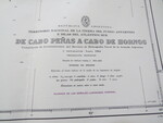
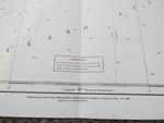
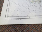
Reference 4053 (2297) Category Maps; Author Buquet, J (Cartographer) Title Argentinian Admiralty Chart No.63 Mercator Projection: De Cabo Penas a Cabo de Hornos Publishing Information Argentina: Republica Argentina Hydrografia,1990 Description 2nd Edition: 1990 Reprint of the 1939 Admiralty Chart with corrections 1991-180-184. Originally published for Servicio Hydrgrafico del Ministerio de Marina, Buenos Aires II 1939. Scale 1:400,000. Territorio Nacional de la Tierra del Fuego, Antardia e Islas del Atlantico Sur. Relief shown by spot heights and hachures. Depths shown by bathymetric isolines and soundings. Map size 87cm x 68cm. Price £40.00 Keywords ISBN Add this to your basket
