Polar Books Catalogue
-
Sections : Antarctic; Arctic; Journal of the Manchester Geographical Society; Maps; Miscellaneous; Mountaineering; General Polar; Scott; Other travel; Whaling;


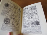
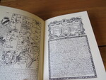
Reference 4089 (2321) Category Maps; Author Bowen, Emanuel Title Britannia Depicta or Ogilby Improved Road Atlas of England and Wales 1731 Publishing Information UK: Britannia Publications Tiverton,1979. 0906689001 Description 1979 facsimile reprint of the 1731 Edition of "Mr. Ogilby's actual survey of all ye direct & principal crossroads in England and Wales: wherein are exactly delineated & engraven, all ye Cities, Towns, Villages, Churches, Seats &c. situated on or near the Roads, with their respective distances in measured and computed miles". Ogilby was the first to use strip maps of the roads of England and Wales. Original covers, no dustjacket. Price £25.00 Keywords ISBN Add this to your basket
