Polar Books Catalogue
-
Sections : Antarctic; Arctic; Journal of the Manchester Geographical Society; Maps; Miscellaneous; Mountaineering; General Polar; Scott; Other travel; Whaling;
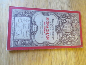

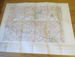
Reference 4096 (2328) Category Maps; Author Wilkinson, B.E. Capt (Engraved at the Ordnance Survey Office Dublin under the supervision of) Title Ordnance Survey One Inch Map of Monaghan and District, Ireland. Coloured Edition: Sheet 58. Publishing Information Southampton: Ordnance Survey, 1902 Description Early Edition: Revised in 1834-5. Revised in 1902, printed in 1903. Folding coloured map on cloth measuring 42 x 56cms folding in 18 panels to approx. 18 x 10cm. Scale One Inch to One Statute mile 1:63360. The cover is Ellis Martin's Royal Arms with mantling in dark red and brown. Small holes on bisections of cloth, as usual. Odd stain but overall a nice copy. Price £15.00 Keywords ISBN Add this to your basket
