Polar Books Catalogue
-
Sections : Antarctic; Arctic; Journal of the Manchester Geographical Society; Maps; Miscellaneous; Mountaineering; General Polar; Scott; Other travel; Whaling;
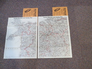

Reference 4119 (2350) Category Maps; Author Dunlop Tyres Title Dunlop Touring Map of Great Britain and Ireland Scale 4 miles to 1 inch, No.6 (Anglesey and NW West Wales) and No. 7 (Cheshire, Shropshirer and NE Wales) Publishing Information Edinburgh: Johnston W. & A.K. Circa 1930s Description 2 folding paper maps, sheet size 38 x 50cm folding in 8 sections into booklet 19.5cm x 13cm. The full set of maps consisted of 44 maps, 12 of which were for Ireland. Undated, but circa 1930. Price £25.00 Keywords ISBN Add this to your basket
