Polar Books Catalogue
-
Sections : Antarctic; Arctic; Journal of the Manchester Geographical Society; Maps; Miscellaneous; Mountaineering; General Polar; Scott; Other travel; Whaling;


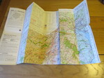
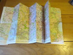
Reference 4121 (2353) Category Maps; Author Ordnance Survey Title Ordnance Survey One-inch Tourist Map of Dartmoor showing National Park Boundary: 1 inch to 1 mile. Publishing Information Chessington: Ordnance Survey, 1967 Description Published and printed in 1967. Folding coloured paper map measuring 105 x 83 cms folding in 36 panels to approx. 21.5 x 13cm. Scale One Inch to One Statute mile 1:63360. Price £5.00 Keywords ISBN Add this to your basket
